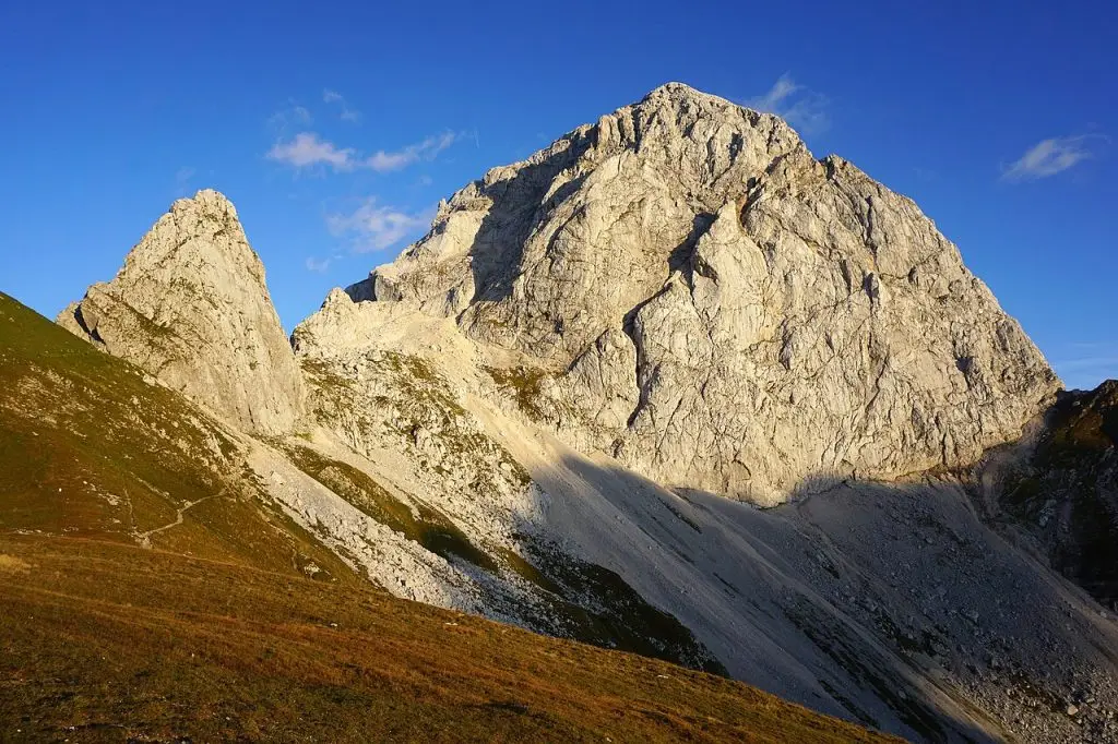
Mangart is a mountain in the Julian Alps on the border between Slovenia and Italy, and it is best known for the Mangart Saddle road, one of the highest roads in Slovenia. If you are searching for Mangart, you are probably planning a drive from Bovec, a hike near the pass, or simply want to know whether the trip is worth the effort. The short answer is yes, in the right season and with the right preparation.
What is Mangart?
The summit of Mangart rises to roughly 2,680 metres, making it one of the major peaks of the Julian Alps. It sits above the Predel pass and the Bovec basin, close to the Italian side with the Fusine lakes. The mountain is popular with experienced hikers and climbers, but most visitors come for the high road and the views from the saddle.
The Mangart Saddle road
The road climbs from the Predel area up to a high saddle where parking and a short walk reward you with big alpine scenery. It is a narrow, winding mountain road with tight bends, so drive carefully and give way where needed. The road is typically open only in the warmer months, and snow can close it early or late, so check current conditions with a local tourist office or the official Slovenian tourism site before you set off.
How to get to Mangart
- From Bovec: Bovec is the usual base. From there you drive towards Predel and then follow the signs for the Mangart road. Allow time for the climb.
- From Kranjska Gora or Tarvisio: You can also approach from the north via the Italian side near Tarvisio, then over the Predel pass.
- Public transport: Services to the high saddle are limited or non-existent, so a car or a local taxi or organised transfer is the practical choice. Check the latest options locally.
- Cycling: Experienced road cyclists enjoy the long climb. Be ready for steep sections and mountain weather.
What to do at Mangart
At the saddle you will find walking paths of different difficulty. Easy options are short strolls with views over the valleys, while more challenging routes lead onwards towards the summit area. Mountain trails here are exposed in places, and you should have the right equipment and experience.
Easy and moderate options
- Walk a short stretch from the car park for panoramic views.
- Take a picnic and sit by the rocks while watching the clouds move.
- Look for alpine flowers in early summer, depending on the season.
Serious mountain routes
Climbing or hiking higher on Mangart is for those with alpine experience. There are exposed ridges and secured sections, and weather in the Julian Alps can change fast. If you are not certain of your skills, hire a local mountain guide from Bovec or Kranjska Gora.
Planning a Mangart day
- Start early. Mornings usually bring clearer views and fewer cars.
- Bring layers. It can be much colder and windier at altitude than in the valley.
- Fuel and brakes. Fill the tank in the valley, and use a low gear on the descent.
- Offline maps. Mobile coverage can be patchy in the mountains.
- Respect the border area. You may see the Slovenia-Italy line on the map; carry ID as a general rule.
Combining Mangart with other stops
The Soča valley is full of options. Bovec is a centre for rafting, kayaking and canyoning on the turquoise Soča river. The Kozjak waterfall, the Boka waterfall and the Kobarid museum, which covers the First World War front in the region, are all within reach. The Vršič pass, a famous high road to the north, is another popular drive.
The area was a major front in the First World War, and traces of that history remain in the landscape. A visit to the Kobarid museum gives you context for the war on the Isonzo front, and the Italian ossuary in Kobarid is a quiet, sobering place.
For more Slovenian ideas, see our travel guides, and for official tourism information visit the Slovenia tourism site.
FAQ
When is the Mangart road open?
Usually in the warmer months only. Exact dates depend on snow, so check locally before you go.
Is the road suitable for any car?
Most standard cars manage it in good conditions if driven slowly, but the road is narrow with sharp curves. Avoid it in bad weather or if you dislike heights.
How long should I allow?
Count a few hours for the drive and short walks, or most of a day if you plan to hike further.